This month’s release involves a cleaner interface, new features (support for different kinds of files), improvements to the Data Mining module, the introduction of Weather Analysis, and many bug fixes and enhancements. Census Tracts (CT) are now supported as a Trade Area! You will find this option on the drop-down while uploading, next to FSA and DA. Additionally, FSA and DA files are now under Area Based Trade Areas. […]
Tag: Statistics Canada
Second Wave of Mortgage Deferrals Coming
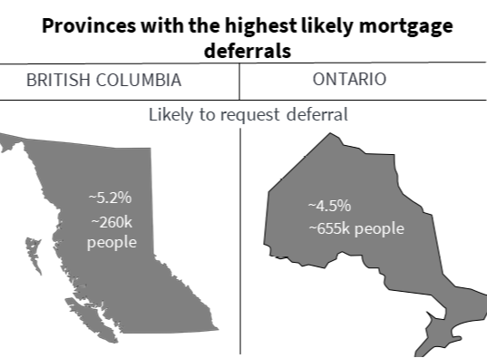
More than 1.5 million Canadians (4% of the Canadian population) will likely ask for a second mortgage deferral in October 2020, and here’s why. Despite partial reopenings, spending on critical sectors is still down. Pre-COVID, 22% of Canadians were employed in these suffering sectors: retail trade (~11% of Canadians), accommodation and food services (~7%), arts (~2%), and real estate (~2%) industries! For RBC in Ontario and BC, that’s $8.5 billion of mortgages at risk! […]
How to Find Your Top Prospects?
Identifying potential customers can be a challenging and time consuming task. Taking a shot in the dark on who and where your targets results in less success when trying to close a prospect. Prospecting is further complicated by the fact that there are many options you can choose to search for your targets. Options range from search engines (be it LinkedIn or Google), to more high end solutions involving surveys and data analysis but these tend to be time consuming and challenging to execute. […]
Release Notes July 27, 2020
This month’s release is a quiet one: bug fixes and performance improvements. You might not notice much other than Polaris running a little faster. If you’re using an adblocker, you’ll get a warning now. Adblockers are known to interfere with the Mapping Centre, particularly Heat Maps. We made improvements to the Data Mining module, including validating data and column headers and user interface simplifications. Contact your account manager for more information […]
Release Notes June 29, 2020
This month’s release includes many exciting updates for Polaris! We updated data/reports, added a new Food Spending Report (everything from amount spent on breakfasts purchased at table-service restaurants to spending on canned tuna), reorganized the structure of our Consumer Behaviour Report Categories, and recategorized our 4-digit NAICS Labour Force and NOC Occupation reports under Profession Patterns. We also made small aesthetics changes, fixed typos and other bugs […]
What is Location Intelligence?
Location intelligence refers to the insights gained from layering a variety of useful geographical information systems (GIS) tools (such as POIs, demographics, geofences, heat maps and thematic maps of variables of interest). Using the layered spatial data, as well as the trends and relationships that these tools offer, businesses can make informed decisions on where to offer their services or operate their business. Use cases include site selection, identifying new customers and markets, […]
Release Notes June 3, 2020
If there was one word to summarize the highlights of this release, it would be “geography”. We added support for a more granular level of geography for Trade Areas and for Thematic Maps. We also added a new report, the “Geography Report”. Of course, in anticipation of a delayed patio season, we also squashed some bugs. We added support for the use of Dissemination Areas (DAs) as Trade Areas. DAs are much smaller than FSAs and a little larger than postal codes, as you can see […]